 david coombe | history
SUMMARY: H. C. Jervis made engravings in Adelaide of landmark buildings in 1841-1842. Initials "C.W.C" on them became an authorship red herring. They may be based on originals by S. T. Gill. There are links too with the 1842 Kingston map.
Article type: CATALOGUE, ANALYSIS
In this article ...
Harry (Henry) Cooper Jervis arrived in Adelaide from London on ship Fairfield in December 1840. He is known in South Australia by his engravings of Adelaide landmarks. They were first advertised at the end of 1841.
THE FINE ARTS IN ADELAIDE. A SERIES of first rate engravings of the principal buildings of Adelaide, by H. Jervis, printed on a sheet of letter paper for the convenience of parties wishing to send
home.
No. 1. Government House, now, ready; proofs 1s. each.
No. 2. Australian Bank, in a few days.
City Engraving & Printing Offices opposite the Royal Oak Hindley-st.1
These two letter papers don't correspond with the four known Jervis engravings in SLSA (B 4499 to B 4502) which are:
Each of these four are captioned: "Engraved, Printed & Publish'd – 1842 – by H. C. Jervis, Adelaide".
Flinders University also has an engraving of similar appearance and period, "Congregational Chapel, Adelaide", but it lacks a Jervis caption and instead has a letterpress one.
Three months later the economic depression forced Jervis to advertise he'd take any goods in payment in lieue of cash2 and six months after that he became a police constable.3 In another six months he quit South Australia for New South Wales.4
The four (or five) engravings are the focus of this article and they have a connection with a contemporary map.
1842 Kingston Map of Adelaide, South Australia
The Kingston map represents colonial Adelaide as at 1 January 1842. An analysis and an interactive map.
The map was the work of George Kingston (Town Surveyor) and Edward Stephens (Bank of South Australia). On 2 February 1842 Stephens sent a case to London aboard Frances Yates and it's possible the original map was in that case.5 The map was published through their agent Edmund J. Wheeler who was manager in England for the South Australian Company.6
In London, Wheeler noted on the map
The Marginal sketches of Buildings are from private copies which may possibly be less perfect than professional drawings. Yet we think they would not be found very inaccurate. 8th Dec'r 1842. E.J.W. & Co.
The buildings illustrated are (clockwise from top left):
On arrival of the published map in Adelaide in July 1843, the building sketches were criticised.
The Southern Australian:
MR. KINGSTON'S splendid map of Adelaide has at last arrived in town. It appears to have been published at the joint cost of that gentleman and of Mr Stephens, Manager of the Bank of South Australia... The only parts for which Mr Kingston is not responsible, are the views of several of the buildings delineated on the margin which are in some degree defective...7
And the Adelaide Observer:
The nooks and corners of the map have been filled up in England by engravings of some of the public buildings; but we regret to add that the sketches from which they are taken not being drawn on the spot, but made up partly from the memory of returned colonists, and partly from imperfect designs, do not give so correct or favourable a picture of the respective elevations as could have been desired. This remark applies particularly to Trinity Chuch and Government House. With this exception the map is immaculate.8
Jervis' Bank of South Australia and Government Offices are the same views as the map, but with people and surroundings. The same applies to the Stow Congregational Chapel.
Was there a common source for the pictures?
The newspaper said Kingston wasn't responsible for the building illustrations on the map's margins. This would suggest Wheeler sourced perspectives from within the South Australian Company. Stephens may have sent Jervis' engravings in his case, or perhaps sketches by another.
The four Jervis engravings in SLSA all have initials "CWC" in the lower image – one has in-between dots to make it very clear these are initials. What do these initials signify?
Wilson & Borrow (1973) claimed this to be C.W. Calvert:
C. W. Calvert, opposite the Royal Oak, Hindley Street, Adelaide, in 1842, made small engravings of Government House; Wesleyan Chapel, Gawler Place, Adelaide; Bank of South Australia; Queen's Theatre; Government Offices; see Adelaide Examiner, 30th December, 1841, p. 1c. (Wilson & Borrow, 267, note 24).
The problem is there is no such person as C. W. Calvert. Nor were there any Calverts in Adelaide then. Wilson & Borrow's newspaper reference (30 December 1841 already cited above) mentions neither Calvert nor those four engravings! This is simply error in a Wilson & Borrow footnote. (Unfortunately it has propagated far!)
Could these prints be later? Calvert & Waddy were Adelaide printmakers in 1850-1851, but they weren't known as Calvert, Waddy & Co. "C.W.C" means something, but we know not what!
Who are other possible artists for the Jervis engravings?
There is no reason to think Jervis engraved his own sketches. James Henderson, surveyor, similarly sketched the bank, but later. Mary Hindmarsh had twelve Adelaide views for publication in London, but earlier.9 E. A. Opie was active around the same time as Jervis.10
The more likely artists are S. T. Gill, professional artist; and F. R. Nixon, surveyor and amateur artist. Gill and Nixon sketched similar subjects and views as can be seen in Nixon's later "Twelve Views":
F.R. Nixon's Twelve Views, &c., 1845
January - June 1845. F.R. Nixon - a somewhat mischievous artist - etched and printed 12 Views of Adelaide in 1845, priced 21 shillings.
Comparing various versions of these views:
The evidence tends to favour the Gill, the young professional artist, as the most likely to have sketched the originals for engraving by Jervis.
To see these works, with accompanying notes, just scroll down or jump to the List of Works.
Scroll down to see all pictures along with detailed notes or click a link to jump to a specific work from the list.
 Queen's Theatre, Adelaide | State Library of South Australia B 4502
Artist: Jervis, H C (after Gill, S T(attr.)?) | Date: 1841-12/1842 | 7.6(H) x 11.1(W) cm
Catalogue page: H.C. Jervis Engravings | 1841/1842
The Queen's Theatre with it's accompanying Shakspeare Tavern and Commercial Exchange (John Lazar). Sign reads: "Miss Lazar's Benefit To-Night". Acre 176.
One of several prominent buildings engraved and printed by H. C. Jervis.
Map | Map of Adelaide (Kingston, 1842)
355
Court House, South Australia | National Library of Australia NK2038/22
Artist: Gill, S.T. | Date: 1842~/1844~
Catalogue page: S.T. Gill's Series of Adelaide Views
These are the buildings (acre 176) modified in 1843 for use as courts and incorporating the Queen's Theatre. They were used from about September 1843 to 1850 after which the courts moved to Victoria Square. The view is from the south on Waymouth Street.
Series of Adelaide Views 14 (from reverse inscription).
Catalogue: Reverse has EJ monogram. Likely Magill-Palmer-EJ provenance.
Map | S. T. Gill - Adelaide
68
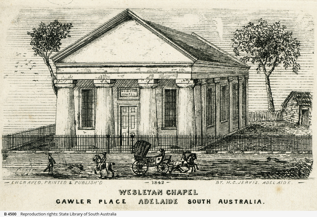 Wesleyan Chapel, Gawler Place, Adelaide | State Library of South Australia B 4500
Artist: Jervis, H C (after Gill, S T(attr.)?) | Date: 1841-12/1842 | 10.5(H) x 16.8(W) cm
Catalogue page: H.C. Jervis Engravings | 1841/1842
The Wesleyan (Methodist) Chapel, acre 106, opened in July 1839 in Gawler Place (which then ran only between Rundle and Grenfell Streets).
One of several prominent buildings engraved and printed by H. C. Jervis.
Map | Map of Adelaide (Kingston, 1842)
478
Front, Methodist Chapel, Gawler Place | National Library of Australia NK2038/08
Artist: Gill, S.T. | Date: 1840~/1841~
Catalogue page: S.T. Gill's Series of Adelaide Views
The newly built Wesleyan (Methodist) Chapel opened in July 1839 in (acre 106) Gawler Place (which then ran only between Rundle and Grenfell Streets). In the background are other buildings in the city, including an industrial chimney stack.
The H. C. Jervis engraving of this building (SLSA B 4500) shows it surrounded by a neat iron fence and, if that is an accurate portrayal, suggests Gill's scene is earlier. Gill advertised his artist's rooms in Gawler Place in March 1840 so this could be one of his earliest colonial works.
Series of Adelaide Views 11 (from reverse inscription).
Map | S. T. Gill - Adelaide
54
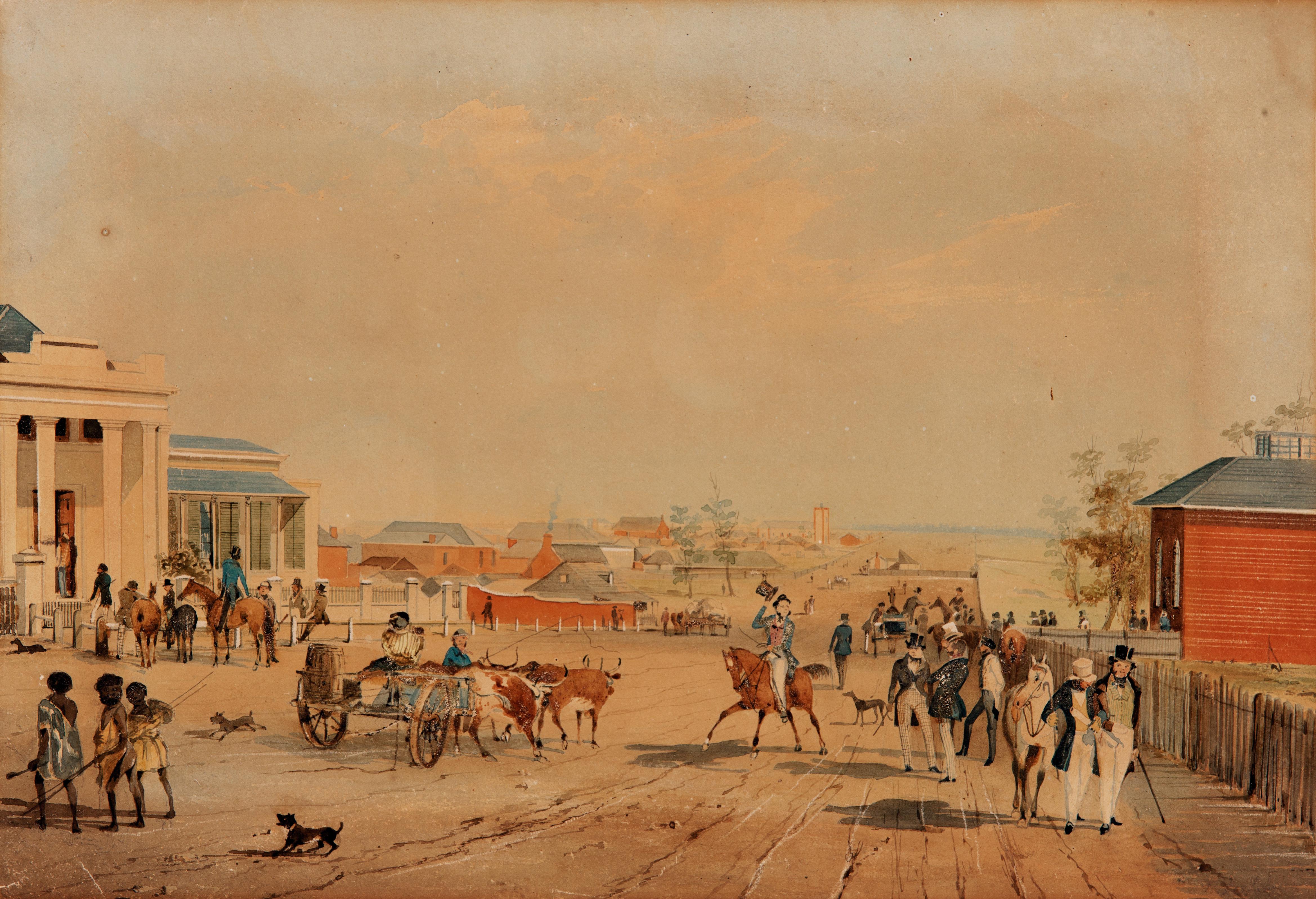
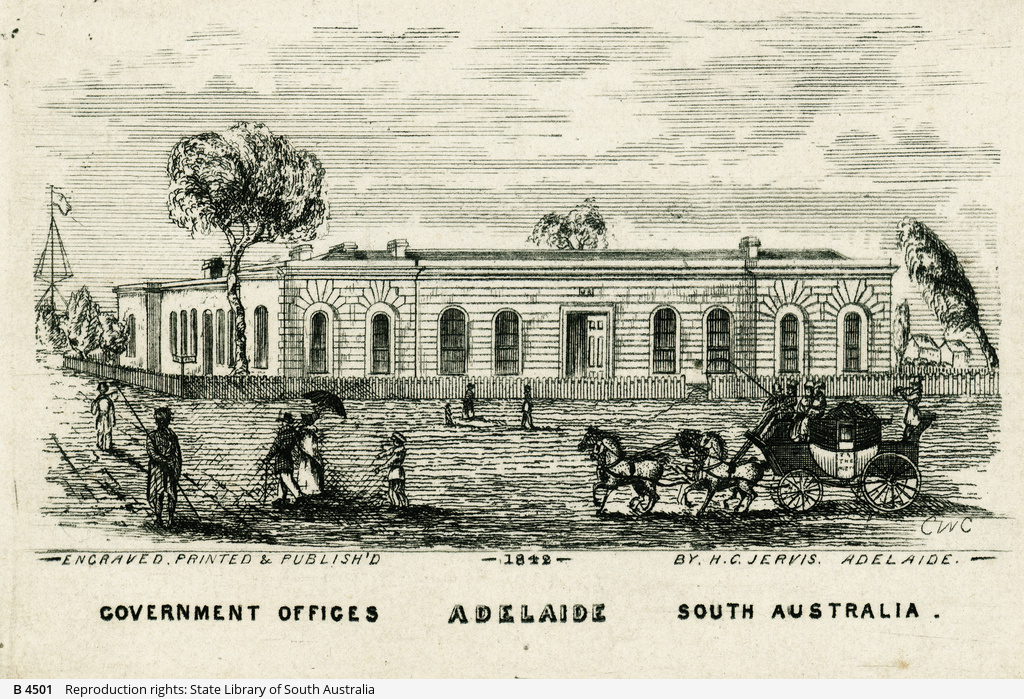 Government Offices, Flinders Street, Adelaide | State Library of South Australia B 4501
Artist: Jervis, H C (after Gill, S T(attr.)?) | Date: 1841-12/1842 | 10.9(H) x 14.8(W) cm
Catalogue page: H.C. Jervis Engravings | 1841/1842
This is a view of the Government Offices, acre 236, from across Flinders Street. At left King William Street leads away to the north with the government flagstaff at the end. A street sign is on the corner. There are people in the scene including an Aboriginal person with long spear. In the foreground is a four-horse public carriage (with bugler) and it's name on the door - seemingly "The Mitre" omnibus. (This makes more sense when considering the engraving is done in reverse for a positive print impression.)
In the 1842 Kingston map, the Public Offices include the Colonial Secretary's Office, Treasury, Assistant Commissar's Office, Surveyor General's Office, Registrar's Office, Auditor Generals Office, Judge's Office and the Bankrupt Court.
One of several prominent buildings engraved and printed by H. C. Jervis.
Map | Map of Adelaide (Kingston, 1842)
477
Government offices facing south, old [...] background | National Library of Australia NK2038/13
Artist: Gill, S.T. | Date: 1845~/1846-06~
Catalogue page: S.T. Gill's Series of Adelaide Views
This is a view of the Government Offices (acre 236) from across Flinders Street. At left is a street sign on the corner where King William Street leads (away) to the north. Background (right) has the old military barracks on Grenfell Street (acre 106). This picture shares all these features in common with the 1841/1842 H.C. Jervis print and the 1845 Nixon lithograph - the latter drawings differ by showing more of King William Street and the government flagstaff at the end.
In the 1842 Kingston map, the Public Offices include the Colonial Secretary's Office, Treasury, Assistant Commissar's Office, Surveyor General's Office, Registrar's Office, Auditor Generals Office, Judge's Office and the Bankrupt Court.
The caption reads "Government Offices [facing?] south [over north?], old [Bks?] background". The artist faces north and the building faces south, so this may explain Gill's correction. So the likely intended caption is: "Government Offices facing south, old Bks [Barracks] background". The regiment moved from the "old" barracks in Grenfell Street (acre 106) to Flinders Street (acre 234) in October 1842.
Series of Adelaide Views 27 (from reverse inscription).
Map | S. T. Gill - Adelaide
59
Government Offices S. view | National Library of Australia U1212
Artist: Nixon, F.R. | Date: 1845-02~/1845-03-22
Primary page: F.R. Nixon's Twelve Views, &c., 1845
No. 2 in Nixon's "Twelve views in Adelaide and its Vicinity, South Australia". This is a view of the Government Offices (acre 236) from across Flinders Street. The open four-wheel carriage and pair may belong to the Governor. At left is a street sign on the corner where King William Street leads (away) to the north. Background (right) has the old military barracks on Grenfell Street (acre 106).
This view is almost identical to Gill's wash drawing NLA NK2038/13 (Series of Adelaide Views). Nixon shows more of King William Street and adds the government flagstaff at the end.
Map | S. T. Gill - Adelaide
499
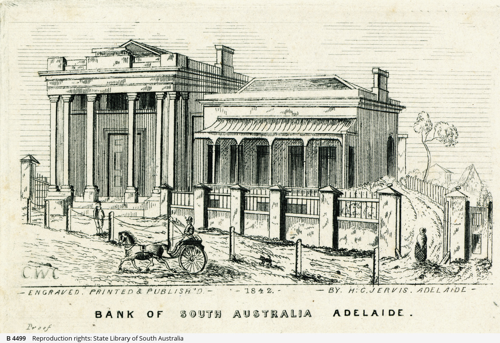 Bank of South Australia, Adelaide | State Library of South Australia B 4499
Artist: Jervis, H C (after Gill, S T(attr.)?) | Date: 1841-12/1842 | 11.3(H) x 16.4(W) cm
Catalogue page: H.C. Jervis Engravings | 1841/1842
Bank of South Australia, acre 15, North Terrace.
One of several prominent buildings engraved and printed by H. C. Jervis.
Map | Map of Adelaide (Kingston, 1842)
479
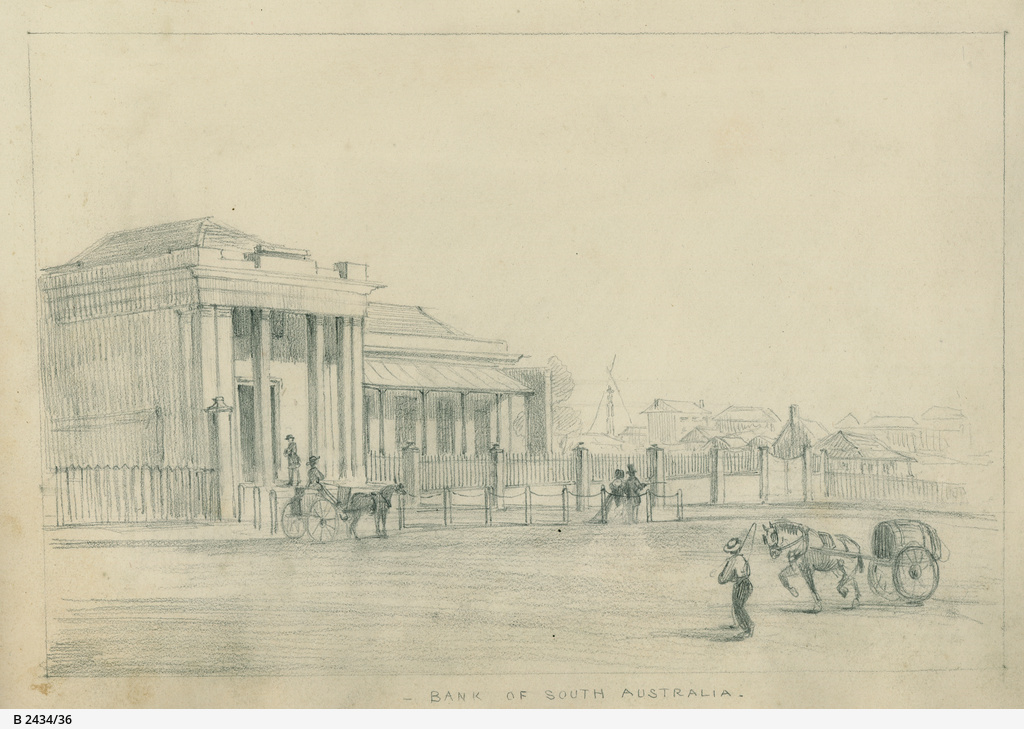 Bank of South Australia | State Library of South Australia B 2434/36
Artist: Henderson, James | Date: 1844~/1845~
Bank of South Australia, acre 15, North Terrace.
Map | S. T. Gill - Adelaide
573
 Bank of South Australia and Legislative Council Room, North Terrace, Adelaide | Art Gallery of South Australia 0.938
Artist: Gill, S.T. | Date: 1845-05~/1845-11 | 27.3(H) x 39.7(W) cm
Catalogue page: S.T. Gill and James Allen, 1845
Looking west along North Terrace, from a position just to the west of King William Street, with the Bank of South Australia (Acre 15) at left of picture and the Legislative Council Room at right. Many top hatted gentlemen are outside these two major buildings. Trinity Church is in the distance. A small "S" or "5" appears on the barrel and the text could be "SG".
The Council Room was used in June 1845 for George French Angas' art exhibition and in February 1847 for the local artists' exhibition.
The opposite view east along North Terrace is shown in AGSA 0.648.
Map | S. T. Gill - Adelaide
24
 Congregational Chapel, Adelaide, 1852, Flinders St. Directory | Flinders University BORS0113018
Artist: Gill, S.T. (after) | Date: 1841~/1842~
Primary page: H.C. Jervis Engravings | 1841/1842
The Congregational Chapel (Stow), acre 205, in Freeman Street (later renamed Gawler Place). Construction was completed at the end of 1840. View from northeast of front and north side (by comparison with <https://collections.slsa.sa.gov.au/resource/B+1206>). Adults, children and a dog are probably heading to chapel. In the background are other buildings in the city, including an industrial chimney stack. Curiously the background is very similar to Gill's "Front, Methodist Chapel, Gawler Place" (NLA NK2038/08). The Flinders image is no longer available online.
This photo of a print was gifted to Flinders by K T Borrow. The rationale for the Flinders catalogue title is unknown - perhaps the image appeared as a plate in an 1852 directory.
The building appears in exactly the same profile on Kingston's map (1842) - see SLSA B 15987, a snippet from the 1842 Kingston map <https://collections.slsa.sa.gov.au/resource/B+15987>. Also of interest are annotated architectural plans (1922): <https://collections.slsa.sa.gov.au/resource/B+5888>
Map | Map of Adelaide (Kingston, 1842)
480
David Coombe. 2021-2025. Original 14 August 2025. Updated 28 May 2026. | text copyright (except where indicated)
CITE THIS: David Coombe, 2021-2026, H.C. Jervis Engravings | 1841 / 1842, accessed dd mmm yyyy, <http://coombe.id.au/S_T_Gill/H_C_Jervis_Engravings_1841_1842.htm>